
Welcome to your definitive guide for hiking in Santa Rosa, meticulously compiled by local experts. Whether you're a resident seeking a new weekend trail or a visitor looking to explore Sonoma County's stunning natural beauty, this list is your starting point. We've curated a selection that showcases the incredible diversity of our local landscape, from gentle lakeside strolls perfect for the whole family to challenging summit climbs offering panoramic vineyard views.
This isn't just a list of names; it's a practical resource. For each of the eight featured trails, you'll find everything you need to know before you go: precise trailhead locations, parking tips, detailed stats like distance and elevation gain, and honest assessments of difficulty. We also include insider advice on kid and dog accessibility, the best seasons to visit, and nearby spots to grab a well-deserved coffee or bite after your adventure. While our guide focuses on day hikes, those inspired to venture further can benefit from understanding the essentials of planning a backpacking trip for longer excursions. Lace up your boots and get ready to discover the best hiking Santa Rosa has to offer.
1. Annadel State Park - Lake Trail Loop
A quintessential Sonoma County experience, the Lake Trail Loop in Annadel State Park is a beloved destination for anyone interested in hiking in Santa Rosa. This moderate 5-mile loop offers a perfect blend of accessible terrain and stunning scenery, making it a local favorite. The trail circles the picturesque Lake Ilsanjo, taking hikers through classic California landscapes of oak woodlands, open grasslands, and chaparral-covered hillsides.
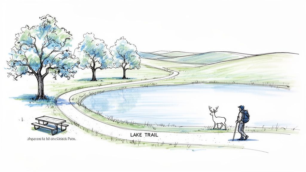
This hike is renowned for its reliable wildlife sightings. It’s common to spot black-tailed deer grazing near the path, wild turkeys foraging in the underbrush, and majestic birds of prey like red-tailed hawks soaring overhead. The well-maintained and clearly marked trail makes it an excellent choice for families with older children and those new to hiking.
Trail Details & Logistics
- Distance: 5.1 miles
- Elevation Gain: 630 feet
- Difficulty: Moderate
- Estimated Time: 2-3 hours
- Dogs: Not permitted on trails.
- Kid-Friendly: Yes, for children accustomed to moderate distances.
Getting There & Park Info
- Address: 6201 Channel Dr, Santa Rosa, CA 95409
- Hours: 8:00 AM to sunset, daily.
- Access Tips: The main parking lot is at the Channel Drive entrance. A day-use fee of $10 per vehicle is required (credit card at the machine or via the Yodel app). Parking can fill up quickly, especially on weekends, so an early start before 9 AM is highly recommended to secure a spot.
- Review Snippet: "A beautiful, classic Sonoma County hike. The views of the lake are fantastic, and we always see deer. It's rocky, so wear good shoes!"
Seasonal Tips & Recommendations
For the best experience, visit during the spring months (March-May) when the hills are vibrant green and dotted with a spectacular array of wildflowers. Autumn also offers pleasant, cooler temperatures and beautiful fall colors. Summer can be very hot and dry, so if you go, start at dawn and bring extra water.
After your hike, you're perfectly positioned to explore more regional attractions. For a comprehensive guide to local dining, wineries, and other activities, explore the many other things to do in Sonoma County to round out your day.
2. Fountaingrove Park - Meadow Loop Trail
For a quick and rewarding nature escape right on the edge of the city, the Meadow Loop Trail at Fountaingrove Park is an outstanding choice for hiking in Santa Rosa. This gentle 2.5-mile loop provides a peaceful journey through classic Sonoma County landscapes, including vast open meadows and serene oak groves. It offers surprising tranquility and beautiful views of the surrounding chaparral-covered hills, making it a perfect spot for a spontaneous afternoon walk or a morning jog.
This trail is exceptionally well-suited for beginners and families with young children due to its relatively flat terrain and short distance. The wide, well-maintained path is easy to follow, allowing you to focus on the peaceful environment and the potential for wildlife sightings. It’s a fantastic way to introduce little ones to the joys of hiking or to simply decompress without committing to a long, strenuous trek.
Trail Details & Logistics
- Distance: 2.5 miles
- Elevation Gain: 285 feet
- Difficulty: Easy
- Estimated Time: 1-1.5 hours
- Dogs: Permitted on leash.
- Kid-Friendly: Yes, excellent for all ages.
Getting There & Park Info
- Address: 1495 Fountaingrove Pkwy, Santa Rosa, CA 95403
- Hours: Sunrise to sunset, daily.
- Access Tips: A dedicated paved parking lot is available at the trailhead. Parking is free but the lot is small and can be limited during peak times, such as weekend afternoons. For a quieter walk, visit on a weekday morning.
- Review Snippet: "Love this easy loop for a quick dose of nature. Great for dogs and kids. The spring wildflowers are gorgeous, but there's not much shade in summer."
Seasonal Tips & Recommendations
Spring is the prime season for this hike, as the meadows explode with vibrant green grasses and a colorful carpet of wildflowers. The mild temperatures of fall also make for a very pleasant experience. During the summer, it's best to go in the early morning or evening to avoid the midday heat, as much of the trail is exposed. Wear sturdy, closed-toe shoes, especially after rain when small creek crossings can be muddy.
3. Spring Lake Regional Park - Dam Trail
For a family-friendly and highly accessible hiking experience in Santa Rosa, the Dam Trail at Spring Lake Regional Park is an unbeatable choice. This versatile 5-mile round-trip trail system offers a mix of paved and dirt paths that wind around the serene Spring Lake. Its gentle terrain, gorgeous water views, and abundance of amenities make it a cornerstone of local outdoor recreation, perfect for a casual stroll, a brisk walk, or a family outing.
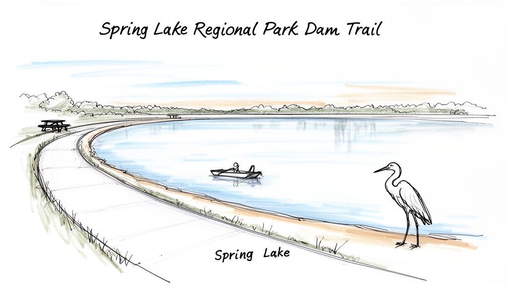
Beyond just hiking, the park is a complete recreational hub. You can enjoy the sandy swimming lagoon, rent paddleboats, or find a scenic spot for a picnic. It's also a fantastic location for birdwatching, so bring binoculars to spot great blue herons, egrets, and ospreys near the water. The park’s connectivity to Annadel State Park and Howarth Park allows for even longer, more varied adventures.
Trail Details & Logistics
- Distance: 5 miles (round-trip)
- Elevation Gain: 115 feet
- Difficulty: Easy
- Estimated Time: 1.5-2.5 hours
- Dogs: Permitted on leash.
- Kid-Friendly: Yes, extremely. The paved paths are stroller-friendly.
Getting There & Park Info
- Address: 393 Violetti Rd, Santa Rosa, CA 95409 (main entrance)
- Hours: 7:00 AM to sunset, daily.
- Access Tips: Multiple lots are available. A day-use fee of $7 per vehicle is required (or free with a Sonoma County Regional Parks membership). Use the Newanga Avenue entrance for slightly less crowded parking on busy days.
- Review Snippet: "The perfect place for a family walk. Paved trails are great for strollers, and the kids love the lagoon. It's our go-to spot on a sunny weekend."
Seasonal Tips & Recommendations
This trail is enjoyable year-round, but the best months are April through June and September through November for pleasant weather. Summer afternoons can get hot, so an early start is wise, perhaps combined with a cool-down at the swimming lagoon. Pack a picnic to enjoy at one of the many tables available.
Spring Lake is a prime example of the incredible local park system. To dive deeper into its history and discover other gems, you can learn more about the Sonoma County Regional Parks journey and what makes them so special.
4. Taylor Mountain Regional Park - Ridgeline Trail
For those seeking a challenging hike with a massive payoff, the Ridgeline Trail at Taylor Mountain Regional Park delivers some of the most spectacular panoramic views in the area. This strenuous out-and-back trail climbs steadily to the mountain's peak, rewarding hikers with sweeping vistas of the Santa Rosa Valley, the distant Diablo Range, and on exceptionally clear days, glimpses of San Francisco Bay. It’s a classic Santa Rosa hiking experience for those ready to tackle a significant ascent.
The trail itself is a wide, exposed fire road, making it a powerful workout as you ascend. While the climb is demanding, the 360-degree views from the top are unparalleled, providing a true sense of accomplishment and a unique perspective on the surrounding landscape. The park is also a working cattle ranch, so don't be surprised to share the open grasslands with grazing cows.
Trail Details & Logistics
- Distance: 4.5 miles (out-and-back)
- Elevation Gain: 1,200 feet
- Difficulty: Strenuous
- Estimated Time: 2-3 hours
- Dogs: Permitted on leash.
- Kid-Friendly: Yes, for older children experienced with steep, sustained climbs.
Getting There & Park Info
- Address: 2080 Kawana Terrace, Santa Rosa, CA 95404 (Main Entrance)
- Hours: 7:00 AM to sunset, daily.
- Access Tips: A paved lot is available at the main Kawana Terrace entrance. A $7 per vehicle day-use fee is required, or you can use a Sonoma County Regional Parks membership pass. The lot often fills by 10 AM on weekends; arrive early or be prepared to wait for a spot.
- Review Snippet: "The climb is no joke, but the views from the top are 100% worth it. Go on a clear day! Very exposed, so bring lots of water and a hat."
Seasonal Tips & Recommendations
An early morning start is crucial, especially from late spring through fall, as the trail has very little shade and can become extremely hot. Be sure to bring at least 2-3 liters of water per person. The best time to hike is in the spring (March-May) when the hills are brilliantly green and wildflowers are abundant. Always be mindful of your surroundings; poison oak can be found along the trail edges, so wearing long layers is a wise precaution.
5. Boyes-Nuns Canyon Trail (Jack London State Historic Park)
For a unique blend of natural beauty and literary history, the Boyes-Nuns Canyon Trail offers an exceptional hiking experience just a short drive from Santa Rosa. Located within the stunning Jack London State Historic Park in Glen Ellen, this challenging 5-mile loop descends into a cool, shaded canyon. Hikers are rewarded with serene redwood groves, a tranquil, babbling creek, and a direct connection to the land that inspired the famous author.
This trail stands out for its immersive, forested environment, providing a wonderful escape from the summer heat. The path winds through the historic grounds of London's "Beauty Ranch," offering a glimpse into the past while you trek. The combination of dense forest, a peaceful canyon, and historical landmarks makes this a truly memorable hike near Santa Rosa.
Trail Details & Logistics
- Distance: 5.0 miles
- Elevation Gain: 1,220 feet
- Difficulty: Challenging
- Estimated Time: 3-4 hours
- Dogs: Not permitted on trails.
- Kid-Friendly: No, best suited for experienced hikers due to steep sections.
Getting There & Park Info
- Address: 2400 London Ranch Rd, Glen Ellen, CA 95442
- Hours: 9:00 AM to 5:00 PM, daily.
- Access Tips: Ample parking is available in several lots near the museum and cottage. A day-use fee of $10 per vehicle is required (payable at the kiosk or entrance station). Grab a trail map at the entrance as the network can be confusing.
- Review Snippet: "What a special place. The hike is tough but rewarding, with beautiful redwoods in the canyon. Make time to see the museum and Wolf House ruins afterward."
Seasonal Tips & Recommendations
Spring is an ideal time to visit when the creek has its best flow and wildflowers line the trail. However, the canyon's deep shade makes it one of the area's best summer hikes. Wear sturdy hiking boots with good traction for the steep and sometimes slippery descents.
After your hike, be sure to explore the rest of the park, including Jack London’s cottage, the "House of Happy Walls" museum, and the ruins of his grand Wolf House. This adds a fascinating historical dimension to your day of outdoor adventure.
6. Sugarloaf Ridge State Park - Bald Mountain Trail
For the experienced hiker seeking a significant challenge and an unparalleled reward, the trek to the summit of Bald Mountain is the premier choice for hiking near Santa Rosa. Located just 30 minutes north of the city in Sugarloaf Ridge State Park, this demanding trail climbs through the Mayacamas Mountains to its 2,729-foot peak. This is a serious undertaking, but the payoff is one of the most breathtaking panoramic views in all of Northern California.
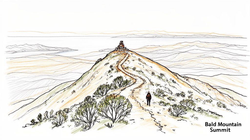
The 360-degree vista from the summit is truly spectacular, encompassing the entire Sonoma Valley, the glistening San Francisco Bay, and on exceptionally clear days, the distant snow-capped peaks of the Sierra Nevada. The trail itself is a journey through diverse ecosystems, from shaded oak forests to exposed, sun-drenched chaparral. This strenuous hike is a bucket-list achievement for any dedicated local or visiting adventurer.
Trail Details & Logistics
- Distance: 8 miles (round-trip)
- Elevation Gain: 2,300 feet
- Difficulty: Strenuous
- Estimated Time: 4-5 hours
- Dogs: Permitted on leash on paved roads and in the campground, but not on backcountry trails.
- Kid-Friendly: No, this trail is best for experienced hikers due to its length and steepness.
Getting There & Park Info
- Address: 2605 Adobe Canyon Rd, Kenwood, CA 95452
- Hours: 8:00 AM to sunset, daily. Hours can vary, so it's always best to check the official park website before you go.
- Access Tips: Parking is available near the visitor center. A day-use fee of $10 per vehicle is required, payable at the entrance station or via an automated pay station. The road into the park is winding; drive with care.
- Review Snippet: "An epic hike with an epic view. It's a tough, steady climb, but the 360-degree panorama from the top is one of the best in Northern California. Start early!"
Seasonal Tips & Recommendations
Spring (April-May) and fall (September-October) offer the most pleasant conditions with milder temperatures and stunning visibility. Summer can be dangerously hot; if you attempt it then, start before sunrise and carry at least 3 liters of water. Sturdy hiking boots, sun protection, and energy snacks are essential year-round. After rain, check trail conditions, as some sections can become muddy and slippery. To learn more about the diverse ecosystems you'll encounter, explore the natural beauty and history of Sonoma County's state parks.
7. Ritchey Canyon Trail - Bothe-Napa Valley State Park
Just a short, scenic drive from Santa Rosa, the Ritchey Canyon Trail in Bothe-Napa Valley State Park offers a refreshing change of scenery. This moderate out-and-back hike follows a picturesque creek deep into a canyon shaded by towering redwoods and lush oak woodlands. It’s an exceptional choice for those seeking the cool, tranquil atmosphere that only a redwood grove can provide.
The trail provides a perfect balance of accessibility and wild, natural beauty. As you meander alongside Ritchey Creek, you’ll encounter small cascades and, in the wet season, a lovely waterfall, making it a fantastic destination for families. This less-crowded alternative provides an immersive nature experience, feeling worlds away from the nearby bustle of Wine Country.
Trail Details & Logistics
- Distance: 5.0 miles (round trip)
- Elevation Gain: 840 feet
- Difficulty: Moderate
- Estimated Time: 2.5-3.5 hours
- Dogs: Not permitted on trails.
- Kid-Friendly: Yes, for children comfortable with creek crossings and moderate distances.
Getting There & Park Info
- Address: 3801 St Helena Hwy, Calistoga, CA 94515
- Hours: 8:00 AM to sunset, daily.
- Access Tips: Parking is available near the trailhead within the park. A day-use fee of $10 per vehicle is required. Arrive early on weekends to secure a spot, as the main lot near the trailhead can fill up.
- Review Snippet: "A wonderful, shaded hike, perfect for a hot day. The redwoods are majestic, and the creek crossings are fun. Great for families with adventurous kids."
Seasonal Tips & Recommendations
Visit from March to May for the best waterfall flow and vibrant spring wildflower displays. Be prepared for multiple creek crossings; water shoes or boots you don't mind getting wet are highly recommended. Always check recent trail reports for creek levels before you go. After your hike, take advantage of the park's excellent picnic facilities for a relaxing lunch among the trees.
8. Huichica Creek Trail - Napa-Sonoma Marsh Wildlife Area
For a completely different kind of hiking near Santa Rosa, the Huichica Creek Trail offers a unique journey through a vital tidal marsh ecosystem. Located about 30 minutes south of the city, this easy, flat trail provides an immersive experience into the wetlands of the Napa-Sonoma Marsh Wildlife Area. Instead of forested mountains, you'll find expansive grasslands and waterways stretching towards the horizon, with views of San Pablo Bay.
This hike is an absolute paradise for birdwatchers. The trail meanders through a habitat teeming with waterfowl, shorebirds, and raptors. It’s a peaceful, wide-open landscape that offers a serene escape and a fantastic opportunity to connect with a different side of Northern California's natural beauty. The simplicity of the trail makes it highly accessible for all skill levels and ages.
Trail Details & Logistics
- Distance: 3.0 miles (out-and-back)
- Elevation Gain: 22 feet
- Difficulty: Easy
- Estimated Time: 1-1.5 hours
- Dogs: Permitted on leash.
- Kid-Friendly: Yes, excellent for all ages due to the flat, easy terrain.
Getting There & Park Info
- Address: Trailhead is located off Hwy 12/121 (Carneros Hwy), near the intersection with Duhig Rd, Napa, CA 94559.
- Hours: Sunrise to sunset, daily.
- Access Tips: Free parking is available in a small, unmarked gravel lot on the south side of the highway. Space is limited but typically sufficient. The trailhead can be easy to miss, so navigate carefully.
- Review Snippet: "A bird watcher's dream! The trail is flat and easy, with incredible views of the marsh. Bring binoculars! It can be windy, so a jacket is a good idea."
Seasonal Tips & Recommendations
The best times to visit are during the spring and fall bird migration seasons, when the sheer variety of avian life is at its peak. An early morning start provides the best light, cooler temperatures, and the most active birdwatching. Be sure to bring binoculars and a bird identification guide to enhance your experience.
Because the area is exposed and can be buggy, wearing light-colored clothing and insect repellent is advisable. After your walk, consider exploring the nearby Carneros wine region or heading into Napa for a well-rounded day trip.
8 Santa Rosa Hiking Trails — Quick Comparison
| Trail | 🔄 Complexity | ⚡ Resources | 📊 Expected outcomes | Ideal use cases | ⭐ Key advantages + 💡 Tips |
|---|---|---|---|---|---|
| Annadel State Park - Lake Trail Loop | Moderate: 5‑mi loop, well‑marked | Low: 15‑min drive from Santa Rosa; free parking (fills); bring 2–3L water | Scenic lake views, wildlife sightings, family‑friendly | Families, casual hikers, wildlife/wildflower viewing | Close to city and well‑maintained. 💡Start early to avoid crowds; $10 park fee |
| Fountaingrove Park - Meadow Loop Trail | Easy: 2.5‑mi loop, minimal elevation | Very low: near downtown; limited parking; bring ~1L water | Peaceful meadow and oak views; quick nature break | Beginners, lunch‑break hikes, families with young children | Highly accessible and short. 💡Visit weekday mornings; wear closed‑toe shoes for creek crossings |
| Spring Lake Regional Park - Dam Trail | Easy–Moderate: 5‑mi RT; paved & unpaved options | Moderate: amenities (restrooms, beach, boat rentals); day‑use fee $10–12 | Strong family recreation: lake views, birdwatching, beach access | Families, multi‑activity outings, birders | Versatile amenities and stroller‑accessible sections. 💡Pack picnic & binoculars; start early |
| Taylor Mountain Regional Park - Ridgeline Trail | Moderate–Strenuous: 4.5‑mi out‑and‑back; ~1,200 ft gain | Moderate–High: limited shade/parking; bring 2–3L water and sturdy shoes | Panoramic valley/mountain vistas and solid workout | Intermediate/advanced hikers; training hikes | Outstanding views and lower crowds. 💡Start very early; watch for poison oak |
| Boyes‑Nuns Canyon Trail (Jack London State Historic Park) | Moderate: 5‑mi loop with elevation change; shaded canyon | Moderate: $15 park fee; limited parking; facilities at park | Cool redwood canyon hike with creek and historical sites | Families wanting culture + nature; history buffs | Unique history + shaded redwoods. 💡Combine with museum visit; wear sturdy boots |
| Sugarloaf Ridge State Park - Bald Mountain Trail | Strenuous: 8‑mi RT; ~2,300 ft gain | High: 30‑min drive; bring 3+L water, sturdy boots; $10 park fee | Premier summit vistas and challenging workout | Serious hikers, summit seekers, photographers | Best panoramic views in the region. 💡Start before sunrise; allow 4–5 hours |
| Ritchey Canyon Trail - Bothe‑Napa Valley State Park | Moderate: 5‑mi RT; ~700 ft gain with creek crossings | Moderate: short drive; limited parking; bring 2L and creek‑ready shoes | Shaded creek hike with seasonal waterfall and wildflowers | Families seeking waterfall destinations; cool creek hikes | Less crowded, cool canyon atmosphere. 💡Visit Mar–May for best waterfall flow |
| Huichica Creek Trail - Napa‑Sonoma Marsh Wildlife Area | Easy: 3‑mi RT; flat terrain | Low: free access; exposed/windy—bring binoculars, repellent, 1–2L water | Excellent birdwatching and marsh/ecology education | Birders, families, beginning hikers, educational trips | Exceptional birding and unique marsh habitat. 💡Visit during migration; wear insect repellent |
Your Sonoma County Adventure Awaits
From the oak-studded hills of Taylor Mountain to the serene marshlands of the Huichica Creek Trail, the options for hiking Santa Rosa and the surrounding Sonoma County landscape are as diverse as they are breathtaking. We've journeyed through eight distinct trails, each offering a unique window into the region's natural beauty. You've seen how a short, accessible loop at Spring Lake can provide a perfect family outing, while a challenging ascent to Bald Mountain at Sugarloaf Ridge rewards the determined with unparalleled panoramic views.
The key takeaway is that Santa Rosa serves as an exceptional basecamp for every type of hiker. Whether you're seeking a quick post-work trek at Fountaingrove Park or a full-day immersion in the volcanic legacy of Annadel State Park, there is a trail waiting for you. This guide equips you with the practical details - trailheads, difficulty ratings, and seasonal tips - to move from inspiration to action.
Making the Most of Your Hikes
To truly master your local hiking experience, remember to apply the insights we've shared. Always check park hours and potential fees before you go; for example, state parks like Annadel and Sugarloaf have day-use fees, while regional parks like Taylor Mountain are typically covered by a Sonoma County Regional Parks pass. Packing layers is non-negotiable, as a cool morning can quickly turn into a warm afternoon, especially on exposed trails like the Ridgeline Trail. Most importantly, practice Leave No Trace principles by packing out everything you pack in, respecting wildlife from a distance, and staying on designated paths to protect fragile ecosystems.
Your Next Steps on the Trail
Your journey doesn't end here. Use this guide as a starting point.
- Pick one trail that resonates with you and plan your visit for the upcoming weekend.
- Prepare your gear: Check your water bottles, pack snacks, download an offline map, and let someone know your itinerary.
- Explore beyond the path: After your hike, visit a nearby cafe or winery mentioned in our excursion tips to complete your Sonoma County experience. For instance, a hike in Jack London State Historic Park is perfectly complemented by a visit to a local Glen Ellen eatery.
Embracing the trails around Santa Rosa is more than just exercise; it's a way to connect with the heart of Sonoma County. It's about finding quiet moments, challenging your limits, and creating lasting memories against a backdrop of stunning natural splendor. The diverse landscapes we've highlighted are an integral part of what makes life here so special. Now, it's your turn to lace up your boots and discover it for yourself. Happy hiking!
Ready to discover even more local gems, from hidden trails to the best new restaurants and weekend events? The Sonoma County Navigator weekly newsletter is your ultimate guide to living like an insider. Subscribe today at Sonoma County Navigator and never miss out on what makes our region incredible.

Sign up for Sonoma County Navigator
Discover Sonoma County! Latest News, places to play, stay, eat, live, shop, learn and more!
No spam. Unsubscribe anytime.


